Showing posts with label Cartography. Show all posts

Historic Maps and Digital Mapping Roundup

.
Historic Maps and Digital Mapping Roundup
"Was your street bombed during the Blitz?" Telegraph, December 6, 2012

The year-long mapping project, devised by geographer Dr Kate Jones of the University of Portsmouth, uses red bomb symbols to illustrate where each bomb landed.>>>

Neal Conan, "'A History Of The World' Through A Mapmaker's Eyes," WWNO npr, November 26, 2012

World maps help us make sense of the world around us, and our place in it.

While mapmakers may portray their world maps as accurate, scientific and neutral, every single one describes the world from a certain worldview and culture. From ancient Babylonia to the Renaissance, cartographers have been driven by politics, religion, emotion and math.
>>>

Edel Howlin, "World Wants A Little Piece Of Texas On A Map," KUHF npr, November 29, 2012

The Texas General Land Office has been selling map reprints since 2002 with sales numbers jumping around November and December. James Harkins is with the Land Office and says many of their holiday orders come from customers across the pond.


“And that’s because during the 19th century there was a mass immigration movement into Texas from Europe and there are dozens of maps of Texas that were written in German that talked about what a great place Texas is. That the hills in the hill country remind Germans of what it’s like back in Germany.”
>>>

Bill Bowden, "Researchers pinpoint historic Prairie Grove sites," Atlanta Journal Constitution, December 9, 2012

The locations were found using a combination of old and new technologies — everything from ground-penetrating radar to shovel tests. Historical descriptions, a map drawn by a Union soldier and aerial photographs from 1941 also provided valuable information.>>>

The Kansas Gold Rush

Dan Allosso

Map of Kansas and Nebraska Territories, 1854
Kansas! For most East and West-coasters, it’s one of those flyover states.  Even for Midwesterners like me, it’s most frequently remembered as a long flat stretch of driving, on the way to someplace else.  With apologies to Kansans, for many other Americans Kansas is either a band from the 70s (“Point of Know Return,” remember? “Dust in the Wind”?), the gray place Dorothy lived before being swept into Technicolor Oz, or the scene of an early, bloody civil war that helped push the nation over the brink between the 1854 Kansas-Nebraska Act and statehood in 1861.

So I was surprised today, when I discovered in a January, 1859 Ranney Letter that “more than two hundred persons in this county” in southern Michigan were planning to go to Kansas in search of gold the following summer.  It hadn’t occurred to me–maybe because I’m familiar with the flat, drive-through Kansas you can see on current maps–that the Nebraska and Kansas Territories extended to the Rocky Mountains and contained quite a bit of what is now Colorado and Wyoming, as well as a big section of the northern foothills (including the Black Hills) that in 1861 would become the Dakota Territory.

In other words, Gold Country.  Between 1854 and 1861, Kansas and Nebraska were part of The West in a way they no longer are.  Fort Laramie, the site of the 1868 Treaty between the U.S. and the Lakota, Dakota, and Arapaho nations, was originally in the Nebraska Territory.  Pikes Peak, now 100 miles south of Denver and 30 miles west of Colorado Springs, was in Kansas.

“How did I miss this?” I thought, with some alarm.  But when I flipped through the pages of books from the “Western” part of my library, such as Patricia Nelson Limerick's The Legacy of Conquest, I find a Kansas and Nebraska embroiled in Stephen Douglas’s expansionism.  Similarly, on my “Impending Crisis” shelf, David Potter’s book of that name devotes many pages to the 1854 Act and to the Lecompton Constitution.  But Lecompton is in the northeastern corner of present-day Kansas, and Stephen Douglas was from Illinois.  The free-state revolutionaries of Topeka and the Bleeding Kansas border war with Missouri were likewise situated on the eastern borders of the present state.

Published by Oliver Ditson, Boston, 1856
On the pages of the Kansas Historical Society’s website, I learned that the people of Kansas were apparently divided in 1859 over whether their state should be a “Big Kansas” including the western gold region, or a “Little Kansas” without it.  Kansas entered the Union in January, 1861, during the (extremely) lame-duck session between Abraham Lincoln’s election and his inauguration, with a population of 107,206.  William Seward had introduced a bill in the Senate in February, 1860, to admit “Little Kansas” under its free-state Wyandotte Constitution, which fixed the border at 102 degrees west longitude, excluding the Rockies.  The bill was defeated by Democrats who opposed Kansas as a free state; but they also objected to the “Little Kansas” borders, saying the Wyandotte convention had exceeded its authority in changing the territorial boundaries.  Were they afraid that the country around Pikes Peak would soon have sufficient population (the target was 93,000) to become yet another free state?

It just goes to show, I guess, how much complex and interesting detail lies just under the surface of the broad brushstrokes we use to integrate local and regional histories into American History.  The Kansas State Historical Society’s site includes a reprint of a 1967 article from their journal written by Calvin A. Gower of St. Cloud (MN) State University, titled “‘Big Kansas’ or ‘Little Kansas, which describes the Pikes Peak gold rush and the controversy over Kansas’ borders.  We’re lucky to have more and more of these resources online at our fingertips.  Does their availability obligate us to rethink the relationship between the broad strokes and the details–at least for the regions where we live, write, and teach?

Roundup: Maps through Time

Randall Stephens

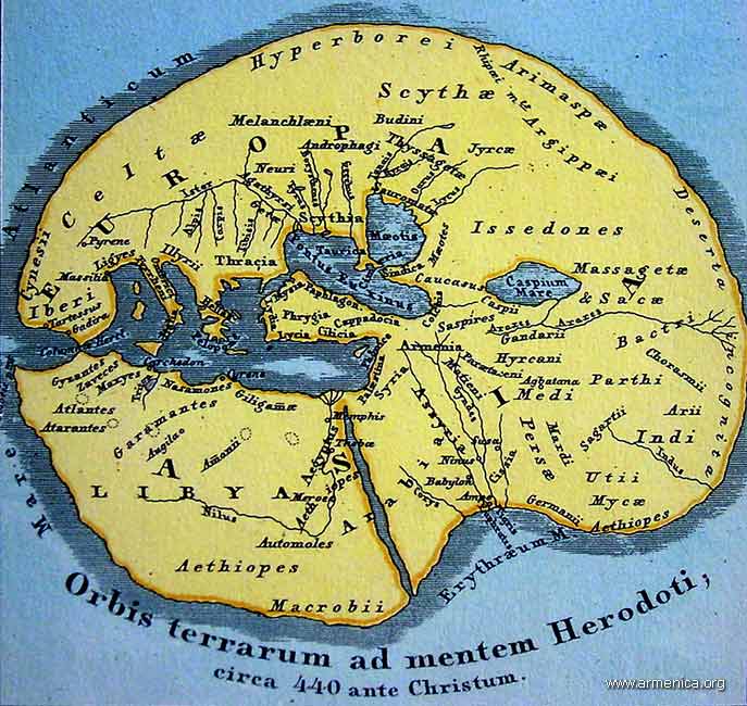
What better way to learn about the past, and what people once made of the world around them, than to study maps? A few days ago I read a fascinating passage in Herodotus: "If, therefore, I judge correctly of these things, the Ionians are mistaken with respect to Egypt; but if their opinion is correct, then I will show that neither the Greeks nor the Ionians themselves know how to reckon, when they say that the whole earth consists of three divisions, Europe, Asia, and Libya; for they ought to add a fourth, the Delta of Egypt, if it be not a part either of Asia or of Libya." A wonderful picture of the world.

I post here some wonderful recent on-line articles dealing with history, cartography, and cultural context. (One piece in particular got me thinking about an iPhone app I'd like to see. How about an interactive historical, walking map of 18th-century Boston? Strolling around the city, the iPhone-toting flaneur would notice that he would be under water were he at this or that place in 1770.)

Michael Church, "The Truth about Maps: How Cartographers Distort Reality," The Independent, March 20, 2010.

As a fascinating new exhibition shows, it's not always what they put in that matters – but what they leave out

What is a map? In effect, says Peter Barber, head of maps at the British Library, a map is a lie. "Unless you have a scale of one-to-one, every map is subjective, and always will be," he explains. "You have to select what you put on it." And selection involves rejection.

Throughout history, such lies have generally served purposes which have been political, religious or philosophical rather than scientific. >>>

Shirley Dent, "Literary London on your iPhone," Guardian Books Blog, March 23, 2010

A new iPhone application which brings the capital's literary heritage to life has made me a hazard on the streets of London. >>>

Cora Lewis,"Maps and Manuscripts Illustrate an Old Worldview," Yale Daily News, March 23, 2010

Napoleon Bonaparte famously had his men re-draw the world’s map to make France larger, but he wasn’t the only historic figure who tried to alter the public’s perceptions with cartography.

“Invented Bodies: Shapely Constructs of the Early Modern,” now on view at the Whitney Humanities Center, features maps and manuscripts from the 15th through 18th centuries, depicting Europeans’ interpretations of their world — from realistic renderings to fantastical imaginings. >>>

Steven Heller, "The World as Their Canvas," New York Times, March 5, 2010

There’s nothing like sitting by the fire with a good book, except maybe sitting by the fire with a good map—or better yet, a good book about maps. I’ve noticed an upsurge in cartographic interest these days, especially for maps’ value as conceptual artwork. >>>

Michael Elliott, "A World Map Under Eastern Eyes," Time, February 25, 2010

What does China really think of the U.S.? Spend some time in the Middle Kingdom, and you'll hear both protestations of admiration and plenty of disparaging comments about the West. Such attitudes have a long history. In 1602 the imperial Chinese court learned that the inhabitants of North America were "kindly and hospitable to strangers." >>>