What better way to learn about the past, and what people once made of the world around them, than to study maps? A few days ago I read a fascinating passage in Herodotus: "If, therefore, I judge correctly of these things,
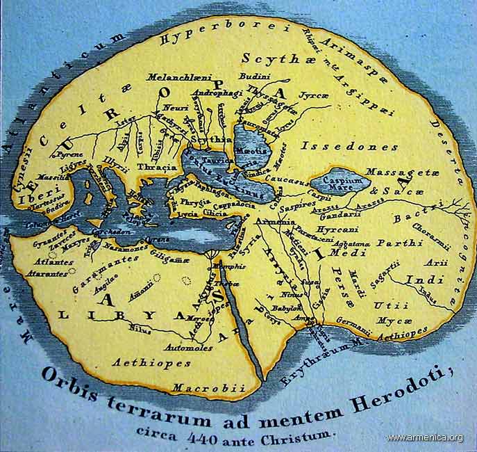 the Ionians are mistaken with respect to Egypt; but if their opinion is correct, then I will show that neither the Greeks nor the Ionians themselves know how to reckon, when they say that the whole earth consists of three divisions, Europe, Asia, and Libya; for they ought to add a fourth, the Delta of Egypt, if it be not a part either of Asia or of Libya." A wonderful picture of the world.
I post here some wonderful recent on-line articles dealing with history, cartography, and cultural context. (One piece in particular got me thinking about an iPhone app I'd like to see. How about an interactive historical, walking map of 18th-century Boston? Strolling around the city, the iPhone-toting flaneur would notice that he would be under water were he at this or that place in 1770.)
Michael Church, "The Truth about Maps: How Cartographers Distort Reality," The Independent, March 20, 2010.
As a fascinating new exhibition shows, it's not always what they put in that matters – but what they leave out
What is a map? In effect, says Peter Barber, head of maps at the British Library, a map is a lie. "Unless you have a scale of one-to-one, every map is subjective, and always will be," he explains. "You have to select what you put on it." And selection involves rejection.

Throughout history, such lies have generally served purposes which have been political, religious or philosophical rather than scientific. >>>
Shirley Dent, "Literary London on your iPhone," Guardian Books Blog, March 23, 2010
A new iPhone application which brings the capital's literary heritage to life has made me a hazard on the streets of London. >>>
Cora Lewis,"Maps and Manuscripts Illustrate an Old Worldview," Yale Daily News, March 23, 2010
Napoleon Bonaparte famously had his men re-draw the world’s map to make France larger, but he wasn’t the only historic figure who tried to alter the public’s perceptions with cartography.
“Invented Bodies: Shapely Constructs of the Early Modern,” now on view at the Whitney Humanities Center, features maps and manuscripts from the 15th through 18th centuries, depicting Europeans’ interpretations of their world — from realistic renderings to fantastical imaginings. >>>
Steven Heller, "The World as Their Canvas," New York Times, March 5, 2010
There’s nothing like sitting by the fire with a good book, except maybe sitting by the fire with a good map—or better yet, a good book about maps. I’ve noticed an upsurge in cartographic interest these days, especially for maps’ value as conceptual artwork. >>>
Michael Elliott, "A World Map Under Eastern Eyes," Time, February 25, 2010
What does China really think of the U.S.? Spend some time in the Middle Kingdom, and you'll hear both protestations of admiration and plenty of disparaging comments about the West. Such attitudes have a long history. In 1602 the imperial Chinese court learned that the inhabitants of North America were "kindly and hospitable to strangers." >>>


